Introduction
“GPS triangulation” is one of the most commonly used phrases in technology—and one of the most technically misused. When people ask, “What is GPS triangulation, and how does it work?” they are usually describing a process that is actually called trilateration. The distinction matters enormously for truly understanding how GPS locates you.
Whether you call it triangulation or trilateration, the underlying mathematics that allows a device to determine its position from satellite signals is one of the most elegant applications of geometry and physics ever put to practical use. In this guide, we explain the real mathematics of GPS positioning—with clarity, accuracy, and seven key facts you may not have known.
Also Read: How Does GPS Work Without Internet? Complete Offline Navigation Explained (2026)
Triangulation vs. Trilateration: The Critical Difference
Before diving into what GPS triangulation is and how it works, it is worth clarifying the terminology:
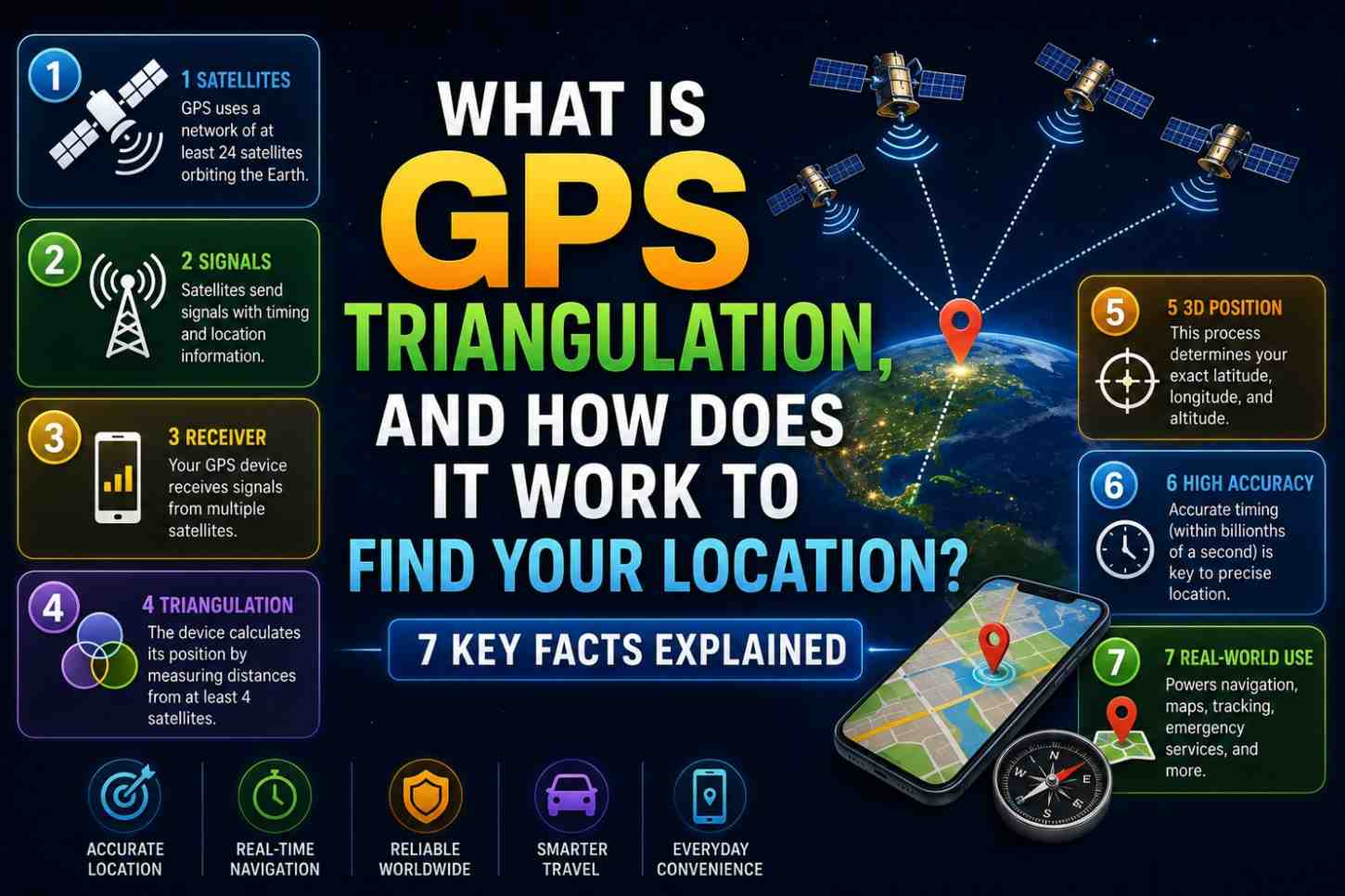
Triangulation uses angles to determine position. Surveyors use triangulation by measuring the angles to known landmarks from different positions to calculate location. It requires measuring direction.
Trilateration uses distances to determine position. GPS calculates distances to satellites based on signal travel time and uses the intersection of those distances to find position. It requires no angle measurement.
GPS uses trilateration, not triangulation.
The confusion is widespread even in major publications and textbooks. Cell phone tower positioning does use a form of triangulation (measuring signal timing angles), which may be why the term became associated with all location technologies.
Throughout this article, we use “GPS trilateration” for accuracy while acknowledging the widely used (if technically imprecise) term “GPS triangulation.”
What Is GPS Trilateration and How Does It Work? The 7 Key Facts
Fact 1: Each Satellite Defines a Sphere, Not a Point
When your GPS receiver determines its distance from one satellite, it knows it is located somewhere on the surface of a sphere—a perfectly round bubble with the satellite at the center and your measured distance as the radius.
For example, if satellite A is 20,500 km away, you are somewhere on a sphere with a radius of 20,500 km centered on satellite A’s position in space.
One satellite gives you a sphere. That is millions of possible positions—completely unhelpful on its own.
Fact 2: Two Satellites Narrow Your Position to a Circle
When you add distance from a second satellite, you have two spheres. Two spheres can intersect in exactly one circle (or not at all, or at exactly one point). You are somewhere on that circle.
This is still thousands of possible positions—much better than a sphere, but still not useful for navigation.
Fact 3: Three Satellites Narrow Your Position to Two Points
A third satellite’s distance sphere intersects the circle from two satellites at exactly two points. One of these points is typically in space or deep underground—physically impossible for a GPS receiver on or near Earth’s surface.
Using Earth’s surface as a constraint, three satellites can technically provide a 2D position fix on Earth’s surface. However, this assumes perfect timing accuracy—which your phone does not have.
Fact 4: You Need Four Satellites to Solve the Clock Error Problem
Your smartphone does not contain an atomic clock. The clock inside your phone is only accurate to microseconds—far too imprecise for GPS timing. A one-microsecond error translates to 300 meters of position error.
The elegant solution: treat your phone’s clock error as a fourth unknown variable in the position equation. With four satellites, you have four equations and four unknowns (latitude, longitude, altitude, and clock error). This system of equations can be solved exactly.
The fourth satellite effectively gives your GPS receiver atomic clock accuracy without actually having an atomic clock—solving for its own clock error mathematically.
Fact 5: More Satellites Mean Better Accuracy (Up to a Point)
Modern GPS chips receive signals from 8–12 satellites simultaneously. More satellites mean:
- Redundancy—if one satellite’s signal is noisy, others compensate
- Better geometry—more spread-out satellite positions improve GDOP
- Overdetermined system—more equations than unknowns allows least-squares optimization
- Faster convergence—position estimates stabilize more quickly
Beyond about 12–15 satellites, additional signals provide diminishing accuracy returns, though they still contribute to reliability.
Fact 6: The Mathematics Runs Dozens of Times Per Second
Your GPS chip does not calculate your position once and stop. It continuously solves the trilateration equations—typically 1–10 times per second (1–10 Hz update rate). Some high-performance chips support up to 50 Hz update rates for applications like precision drone navigation.
This continuous recalculation is why the blue dot on Google Maps moves smoothly as you walk or drive rather than jumping in discrete steps.
Fact 7: Satellite Geometry Affects Accuracy as Much as Signal Strength
Even with perfect signal strength, poor Dilution of Precision (DOP)—the geometric arrangement of satellites in the sky—can significantly degrade accuracy.
Ideal satellite geometry: satellites spread widely across all quadrants of the sky at varying elevations. This provides strong distance constraints from multiple independent directions.
Poor satellite geometry: satellites clustered in one region of the sky. This provides weak constraints in other directions—like trying to triangulate your position from multiple GPS satellites all directly overhead.
GPS receivers report a PDOP (Position Dilution of Precision) value—lower is better. A PDOP under 2 is excellent. Over 6, accuracy degrades significantly.
How Cell Tower Triangulation Differs From GPS Trilateration
Cellular network positioning does use true triangulation—measuring the angle and timing of signals from multiple towers:
| Aspect | GPS (Trilateration) | Cell Towers (Triangulation) |
|---|---|---|
| Measurement | Distance (signal travel time) | Signal timing and angle |
| Number needed | 4+ satellites | 3+ towers (preferably) |
| Accuracy | 1–5 meters | 100m–3km |
| Availability | Requires sky view | Works indoors |
| Signal source | Satellites at 20,200 km | Ground towers, 1–50 km |
Real-World Example: Walking Through the GPS Math
Suppose three GPS satellites report these distances to your receiver:
- Satellite A: 20,187 km away
- Satellite B: 20,533 km away
- Satellite C: 20,312 km away
Your receiver draws three spheres using these radii. The spheres intersect at two points. One point is in outer space. The other is on Earth’s surface—at your location.
A fourth satellite’s distance measurement is then used to correct for your phone’s imprecise internal clock, refining the position to its final accurate value.
This entire calculation happens in microseconds, continuously, across 8–12 satellites simultaneously.
FAQs: What Is GPS Triangulation and How Does It Work
Q1: What is GPS triangulation in simple terms? It is the process of calculating your exact location by measuring your distance from multiple GPS satellites and finding where those distances intersect—though technically the correct term is “trilateration.”
Q2: What is the difference between GPS triangulation and trilateration? Triangulation uses angles to determine position. Trilateration uses distances. GPS uses distance measurements from satellite signal travel times, making it trilateration technically.
Q3: How many satellites does GPS triangulation need? Three satellites for a basic 2D position. Four satellites for full 3D positioning with clock error correction. More satellites improve accuracy and reliability.
Q4: Can GPS work with just three satellites? Technically yes for 2D positioning at sea level, but accuracy suffers significantly without the clock correction provided by a fourth satellite.
Q5: Does cell tower triangulation use the same math as GPS? Cell tower positioning uses a combination of timing measurements and signal strength—related but not identical to GPS trilateration.
Q6: What is GDOP, and why does it matter for GPS accuracy? GDOP (Geometric Dilution of Precision) measures the geometric arrangement of satellites. Low GDOP (satellites spread widely) means high accuracy. High GDOP (satellites clustered) means reduced accuracy.
Conclusion
Now you have a rigorous answer to what GPS triangulation is and how it works—including the important clarification that GPS actually uses trilateration. Four satellites. Four unknowns. An elegant mathematical solution that gives your pocket device atomic clock accuracy without an atomic clock. Whether you call it triangulation or trilateration, the geometry behind your blue dot is one of the most beautiful intersections of physics, mathematics, and engineering in everyday technology. Explore the live satellite geometry above you right now at GPS.gov Satellite Status and dig deeper into positioning mathematics at NOAA’s GPS Accuracy page